CIP Enrollment
Click on a state to display the focal area details. For resources available to state quail coordinators, visit
QuailCount.org.
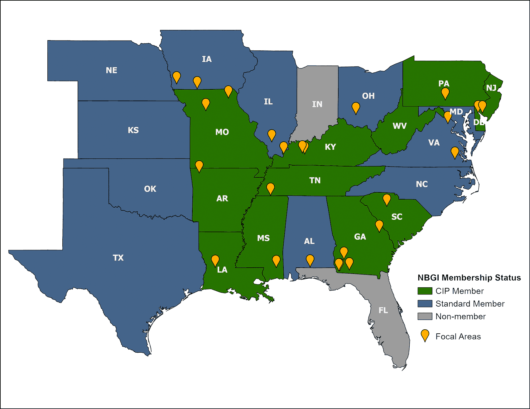
Iowa
Ringgold Focal Area
Acreage: 6,475 acres
Monitoring Points: 32 points
Collecting Data Since: 2013
Shawtee Focal Area
Acreage: 5,812 acres
Monitoring Points: 30 points
Collecting Data Since: 2014
Missouri
2C Focal Area
Acreage: 5,242 acres
Monitoring Points: 24 points
Collecting Data Since: 2013
Bee Ridge Focal Area
Acreage: 5,574 acres
Monitoring Points: 23 points
Collecting Data Since: 2018
Arkansas
Pea Ridge Focal Area
Acreage: 4,250 acres
Monitoring Points: 12 points
Collecting Data Since: 2017
Louisiana
Kisatchie National Forest – Vernon Focal Area
Acreage: 5,991 acres
Monitoring Points: 25 points
Collecting Data Since: 2017
Illinois
Burning Star Focal Area
Acreage: 4,451 acres
Monitoring Points: 24 points
Collecting Data Since: 2018
Kentucky
Livingston Focal Area
Acreage: 5,838 acres
Monitoring Points: 48 points
Collecting Data Since: 2013
Peabody Focal Area
Acreage: 3,074 acres
Monitoring Points: 14 points
Collecting Data Since: 2018
Wendell Ford Training Center Focal Area
Acreage: 3,088 acres
Monitoring Points: 13 points
Collecting Data Since: 2018
Tennessee
Wolf River Focal Area
Acreage: 3,119 acres
Monitoring Points: 13 points
Collecting Data Since: 2018
Mississippi
Leaf River Focal Area
Acreage: 3,549 acres
Monitoring Points: 15 points
Collecting Data Since: 2020
Alabama
Boggy Hollow Focal Area
Acreage: 6,878 acres
Monitoring Points: 24 points
Collecting Data Since: 2018
Ohio
Fallsville Focal Area
Acreage: 11,058 acres
Monitoring Points: 42 points
Collecting Data Since: 2015
Georgia
Silver Lake Focal Area
Acreage: 4,664 acres
Monitoring Points: 22 points
Collecting Data Since: 2018
Chickasawhatchee WMA Focal Area
Acreage: 7,000 acres
Monitoring Points: 48 points
Collecting Data Since: 2020
South Carolina
Indian Creek Focal Area
Acreage: 2,685 acres
Monitoring Points: 12 points
Collecting Data Since: 2016
Focal Area #2
In Development
Virginia
Big Woods/Piney Grove Focal Area
Acreage: 7,574 acres
Monitoring Points: 31 points
Collecting Data Since: 2013
Manassas National Battlefield Park Focal Area
Acreage: 4,424 acres
Monitoring Points: 19 points
Collecting Data Since: 2018
Pennsylvania
Letterkenny Focal Area
Acreage: 3,756 acres
Monitoring Points: 15 points
Collecting Data Since: 2017
New Jersey
Dix WMA Focal Area
Acreage: 6,146 acres
Monitoring Points: 15 points
Collecting Data Since: 2019
Delaware
Cedar Swamp Focal Area
Acreage: 1,694 acres
Monitoring Points: 14 points
Collecting Data Since: 2016